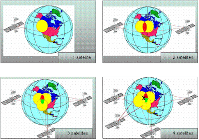
· 1 satellite:
Suppose a GPS receiver turned on and picks up the signal of 1 satellite. The receiver tells the location of the satellite and the distance between the receiver and the satellite. But this single measurement is not a big help. At best, we can conclude that the point position given is within a rather large circle whose circumference is determined by the distance from the satellite. We are still lost.
· 2 satellites.
Now suppose that the GPS receiver picks up signals from another satellite. This helps to narrow down the location and the location is somewhere within the intersection of 2 large circles. We still do not know the exact position of the point, but things are starting to look better.
· 3 satellites.
Let’s go one better. If the receiver picks up signals from a third satellite, then the position will be known to be within the intersection of 3 circles. Now we have the position but no check on its quality.
· 4 satellites.
With 4 satellites we will get a precise point for the position and also the elevation. Here, we have a position that is accurate to 30 metres.
Tiada ulasan:
Catat Ulasan