Differential GPS is an enhancement and a method of increasing the accuracy of positions derived from GPS receivers. There are 3 main components in performing this system which are;
Ä Base station.
Ä Rover station.
Ä Radio link.
It uses a network of fixed ground based reference station to broadcast the difference between the positions indicated by the satellite system and the known fixed position. This station broadcast the difference between the measured satellite pseudo range and actual (internally computed) pseudo range, and receiver station may correct their pseudo range by the same amount. This correction will be sent by radio link.With DGPS, position accuracy is improved, going from 30 metres to better than 10 metres. This system requires at least 2 GPS instruments (receivers & antennas) transmitting positions from at least 4 GPS satellites. 1 GPS instrument set up on a base station with known position and the other 1 set up on a static or dynamic rover station with unknown position.
Rabu, 31 Disember 2008


POSITIONING SATELLITES
GPS receivers use the principle of "ranging". The receiver measures the distance from a location on earth to the positions of several satellites to determine the latitude and longitude of the position on earth. In all GPS observation, at least 4 GPS satellites need to be observed simultaneously.
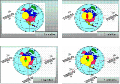

· 1 satellite:
Suppose a GPS receiver turned on and picks up the signal of 1 satellite. The receiver tells the location of the satellite and the distance between the receiver and the satellite. But this single measurement is not a big help. At best, we can conclude that the point position given is within a rather large circle whose circumference is determined by the distance from the satellite. We are still lost.
· 2 satellites.
Now suppose that the GPS receiver picks up signals from another satellite. This helps to narrow down the location and the location is somewhere within the intersection of 2 large circles. We still do not know the exact position of the point, but things are starting to look better.
· 3 satellites.
Let’s go one better. If the receiver picks up signals from a third satellite, then the position will be known to be within the intersection of 3 circles. Now we have the position but no check on its quality.
· 4 satellites.
With 4 satellites we will get a precise point for the position and also the elevation. Here, we have a position that is accurate to 30 metres.
Suppose a GPS receiver turned on and picks up the signal of 1 satellite. The receiver tells the location of the satellite and the distance between the receiver and the satellite. But this single measurement is not a big help. At best, we can conclude that the point position given is within a rather large circle whose circumference is determined by the distance from the satellite. We are still lost.
· 2 satellites.
Now suppose that the GPS receiver picks up signals from another satellite. This helps to narrow down the location and the location is somewhere within the intersection of 2 large circles. We still do not know the exact position of the point, but things are starting to look better.
· 3 satellites.
Let’s go one better. If the receiver picks up signals from a third satellite, then the position will be known to be within the intersection of 3 circles. Now we have the position but no check on its quality.
· 4 satellites.
With 4 satellites we will get a precise point for the position and also the elevation. Here, we have a position that is accurate to 30 metres.
Land Survey Datum (LSD)
= It is used for engineering project.
= Usually used the vertical datum from established BM.
LSD is differing from MSL because reduced level from established BM is referring to MSL at Klang Port.
=Reduced sounding refer to LSD can merge with land details refer to vertical datum from established BM.
= Usually used the vertical datum from established BM.
LSD is differing from MSL because reduced level from established BM is referring to MSL at Klang Port.
=Reduced sounding refer to LSD can merge with land details refer to vertical datum from established BM.
Chart Datum (CD)

=This is the datum plane adopted by the national authority for its published chart and tidal predictions.
= The datum only is used around of tidal observation.
= It is different at different locations.
= Depends on the range of tidal or water level.
= It will only be the same as the SD when the Hydrographic Office has analyzed the survey data and confirmed the suitability of field surveyor’s choice. The surveyor cannot establish CD in field.
= CD is defined by the International Hydrographic Bureau (IHB) as a level below which the tide will but seldom fall.
= In none-tidal waters, CD is normally established at MSL.
= Because LAT is so difficult to define precisely, CD for Admiralty and Australian charts has been more broadly defined as the level below which no predicted tide shall fall more than 0.1m.
Sounding Datum (SD)
= This is the datum plane to which soundings are reduced in the course of a hydrographic survey and is therefore the datum used when compiling the Fair Chart or Final Tracing.
= It is the datum which the field surveyor will establish and adopt.
= Ideally SD should be the same as Chart Datum (CD), but may well differ particularly when the original survey is very old.
= One of these methods is to be used when establishing datum;
· Recover a previously established SD or CD in the survey area by leveling from benchmarks.
· Transfer datum from a place close to the survey area where CD or SD is already established, by taking simultaneous tidal observations over a period.
· Establish a new datum from observations.
= It is the datum which the field surveyor will establish and adopt.
= Ideally SD should be the same as Chart Datum (CD), but may well differ particularly when the original survey is very old.
= One of these methods is to be used when establishing datum;
· Recover a previously established SD or CD in the survey area by leveling from benchmarks.
· Transfer datum from a place close to the survey area where CD or SD is already established, by taking simultaneous tidal observations over a period.
· Establish a new datum from observations.
Lowest Astronomical Tide (LAT)
= LAT is the lowest level that can be predicted to occur under average meteorological conditions and under any combination of astronomical conditions.
= There is no simple formula or rule available to calculate LAT from observations or tidal constituents.
= It can only be obtained properly by studying tidal predictions covering several years (18.6 years ideally), as level of LAT will not be reached every year.
= There is no simple formula or rule available to calculate LAT from observations or tidal constituents.
= It can only be obtained properly by studying tidal predictions covering several years (18.6 years ideally), as level of LAT will not be reached every year.
Mean Tide Level (MTL)
=This must never be confused with MSL.
= MTL is defined as the mean of all HWS and LWS over a period of time.
= It is not (at present) possible to convert simply from MSL to MTL (or vice versa) at any point.
= MTL and MSL will only coincide when tidal curve is a perfect sine curve and this rarely occurs.
= MTL is defined as the mean of all HWS and LWS over a period of time.
= It is not (at present) possible to convert simply from MSL to MTL (or vice versa) at any point.
= MTL and MSL will only coincide when tidal curve is a perfect sine curve and this rarely occurs.
Langgan:
Catatan (Atom)